
We look at the evolution of state spatial strategies through the lens of the three pillars of sustainability i.e. environment, economy and society with two proposals/examples. We also get links to the details for of the two proposals. This chapter is part of a series on Hierarchical Spatial Planning Framework
For addressing the challenges and issues economic disparity, water constraints, or other sectoral conflicts and land use planning challenges as discussed earlier in Chapter 14, a state level spatial strategy can ensure that use of land is in general driven by its most economical and least environmental impact.
A state spatial strategy would ideally advocate assigning priority areas for economic development, no development as well as conservation and augmentation of water. This can improve economic competitiveness along with more equitable income distribution as compared to a scenario of continued water scarcity.
Let us look at the evolution of state spatial strategies through the lens of the three pillars of sustainability i.e. environment, economy and society for the two cases of Odisha and Tamil Nadu. (Please note that these state spatial strategies were a proposal and yet to be formally accepted by either of the state governments. Since the draft state spatial strategies were formulated over a year ago, there are possibilities that there might have been some substantial/non-substantial changes in the same, which are not reflected in this case study. That said, the case studies may still be treated as good examples on evolving a state spatial strategy for any state in India.)
Environment
Forests and Protected Areas
To meet stipulations of National Forest Act 1988, The Department of Environment and Forests in Tamil Nadu intends to increase the forest and tree cover to 30% of total geographical area by 2025 and 33% by 2030, while conserving dense forest areas (with crown density >40%) covering approximately 8676 sq.km. This effectively means a change in land use for about 10% of the overall areas of the state. This will be achieved by demarcating district/block wise spatial distribution of land for identifying additional area of 10321 sq.km. that can come under forest and tree cover (TOF) including plantations.
Both states will ensure safe management of wildlife corridors through participation of local communities, line department, and civil society organizations and Joint Forest Management through Village Forest Committees (Vana Surakshya Samitis, Palli Sabha and Eco Development Committees in case of Odisha) to rehabilitate, restore and re-afforest degraded and open forests (crown density <40%). They will also protect forests (with crown density 40% – 60%) adjacent to settlements from further degradation, especially in the western districts of Tamil Nadu bordering the states of Kerala and Karnataka and the districts with extensive mining activities in Odisha. Both states will notify key movement corridors and possibly acquire them for linking protected areas.

Odisha will focus on the five elephant reserves along with the protected area network to ensure minimum conflicts with human settlements. Odisha will encourage people to voluntarily shift to urban settlements in vicinity.
Odisha will also evolve well defined guidelines and monitoring systems to add buffer to mining and quarrying activities to reduce impact on small animals, birds and nearby agricultural and forest areas. They will also intensify actions for forest fire control under CAMPA and Centrally Sponsored Plan Scheme i.e. Forest Fire Prevention and Management (Ex-Intensification of Forest Management).
Both states being coastal states, will notify and improve/develop mangroves and coastal shelter belt plantations as bio-shield/forests to facilitate implementation of Coastal Zone Management Plan.
Furthermore, Odisha will increase focus on conservation of marine turtles (Olive Ridley sea turtles) and other marine fauna under integrated coastal zone management in major breeding grounds in Odisha (river mouths of Dhamra, Devi, and Rushikulya as well as Mahanadi, Subarnarekha, Budhabalanga, Keluni and Bahuda) and promote river and large waterbodies management plans to conserve ghariyal, salt water crocodiles and mugger etc.
Odisha will demarcate sensitive bio-diversity hotspots as complete no-go zones for land transfer for non-forest activities.
Odisha will also promote silvi-pastoral-culture research to promote plantations and improving green cover especially in degraded lands, defunct mines and existing mining districts with a focus on Sundergarh, Angul, Koraput, Jharsuguda.
Both states state will identify and regulate eco-tourism hotspots as a subset of conservation measures using well defined strategies involving local communities with due consideration to carrying capacity.
Conservation and Augmentation of Water Resources
Tamil Nadu will map critical/semi-critical and over exploited zones/blocks for groundwater and reduce dependence on them by not opening them for industries and shifting cropping pattern from water intensive crops (like paddy) to less water intensive crops.

The state will demarcate important water bodies as protected areas and prevent encroachment /blockage of natural drainage pattern by managing river basin catchment area and formulate region specific guidelines for Protected and Unprotected Aquifer Recharge Areas. Polluting activities like mining, polluting industries, use of fertilisers and pesticides etc. would either not be allowed or will be allowed with restriction in such areas by Odisha.
Tamil Nadu will reinitiate/integrate and further strengthen programmes for Joint Forest Management, Participatory Watershed Development and Participatory Irrigation along with Participatory Ground Water Governance (Pani Panchayats) especially in districts bordering Kerala and Karnataka and districts that are part of Cauvery basin.
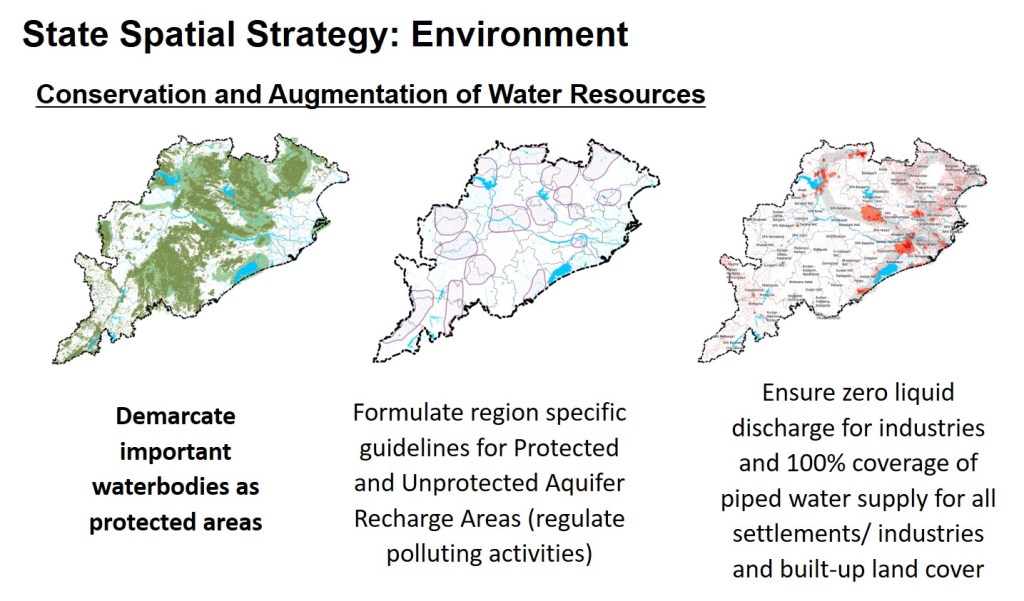
Both states will ensure that industries adhere to the zero liquid discharge and recycling of water for industrial use especially in identified water scarce blocks and polluted waterbodies. Both states will also facilitate, implement, manage, monitor and invest in 100% coverage of piped water supply for all settlements/industries and built-up land cover to facilitate PWD in reducing / completely stop/ ensure minimal tapping of ground water for domestic or industrial use by individuals.
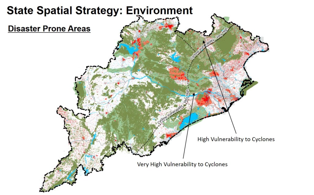
Disaster Prone Areas
Tamil Nadu is vulnerable to natural hazards such as cyclones, tsunamis, floods and drought. Whereas, 13 districts of Tamil Nadu are vulnerable to high or very high cyclonic impact and flooding, at least seven districts are regularly impacted by drought conditions.
Mapping and clear demarcation of natural hazards and disaster vulnerable areas has been undertaken by Revenue and Disaster Management Department recently. Major Accident Hazards will be identified and integrated to existing information to assess vulnerability of settlements.

Odisha is extremely vulnerable to disasters. Odisha will focus on disaster resilient developments by further strengthening its coastal disaster risk reduction programme, with clear demarcation of no-go zones and major accident hazard vulnerability in the districts of Baleshwar, Bhadrak, Jajpur, Kendrapada, Jagatsinghpur, Cuttack, Khurda, Puri, Ganjam and parts of Gajapati, Dhenkanal, Kendujhar and Mayurbhanj. These districts are not only vulnerable to very high cyclonic impact and flooding, they form part of the rice bowl. They also happen to be the districts witnessing rapid development and upcoming investments in secondary and tertiary economy.
Odisha will also focus on the districts of Malkangiri, Koraput, Kandhamal, Gajapati, Kendujhar and parts of Ganjam to reduce incidences of forest fire and encourage voluntary relocation of vulnerable population to settlements outside forest areas.
Both states will focus Investments and incentivise:
- Conserving and creating mangrove forests as bio shields against coastal hazards
- Harnessing flood water and ensure maintenance of natural drainage pattern especially in Aquifer recharge zones
- Checking unregulated growth of settlements in forest periphery, eco-sensitive areas, aquifer recharge areas and influence area of Major Accident Hazards (MAHs).
- Encouraging crop diversification and alternative employment in disaster and drought prone districts.
Economy
Agriculture and Livestock
Both states realise that capping non-agricultural land requirements from food security perspective arrests possibilities of other highly remunerative developments as well as acts as a disincentive for agricultural productivity.
Tamil Nadu
According to the state Human Development Report 2017, there will be a supply-demand gap of about 14100 MCM (29.7 per cent) for water in 2025 with about 70% demand from agriculture. Hence, Tamil Nadu’s agriculture will be looked at from the perspective of use of water and productivity.
Continued emphasis on increasing agricultural productivity especially in dryland areas and marginal lands will achieve production targets in wake of shrinking land and water resources. These are the areas with low or very low base yield levels and have potential for substantial improvement in productivity.
Increasing productivity per unit of land increases productivity per unit of other resources such as water and labour. However, in recent times there is deceleration in productivity growth in irrigated agriculture in several parts of the state.
The state will shift focus towards increasing net income per unit area of land. This will enable farmers to invest in modern, land saving technologies in future. Alternative employment and farm linked value addition will be priority in districts of Thiruvarur, Thanjavur and Nagapattinam.
Farmers will be encouraged to shift to less water intensive crops as well as technologies that would enable cultivating paddy with relatively less water. The state will consider reduce areas under paddy cultivation especially in critical, semi-critical and over exploited ground water blocks. Thanjavur, Nagapattinam, Villupuram will be taken up on priority basis for such initiatives.
Tamil Nadu produces 3% of country’s food grains production, 7% of vegetable production, 12% of fruits and as high as 24% of flower production. There appears to be a shift towards horticulture crops which are high value and can be key to doubling farmer’s income. Dindigul, Krishnagiri, Salem, Erode, Trichy, Dharmapuri and Namakkal are prominent districts for horticulture and floriculture and require timely transportation to the market destinations, cold storage and pack houses near major production centres.

Odisha
The fertile and highly productive land in coastal districts of Baleshwar, Bhadrak, Jajpur, Kendrapada, Cuttack, Jagatsinghpur, Puri, Khurda, Nayagarh and Ganjam are increasingly becoming urbanised. The now urbanised areas in these districts had seen large investments in irrigation and other investments in agriculture in the past, leading to rapid loss of irrigated areas.
Hence, Odisha’s agriculture will be looked at from the perspective of improved irrigation, farm mechanisation, organic farming and postharvest logistics and management, precision agriculture and cooperative farming techniques to increase the crop productivity and diversification.
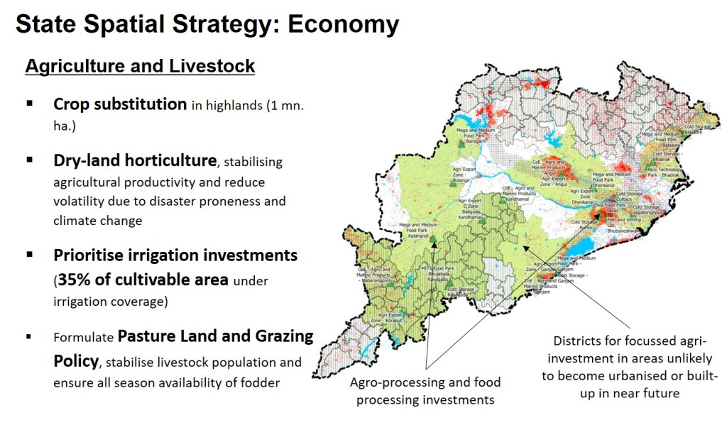
The state will focus on crop substitution in highlands (over an area of about 1 million hectares), along with dry-land horticulture, stabilising agricultural productivity and reduce volatility due to disaster proneness and climate change in oil seeds, paddy and pulses, especially in the Middle Mountain and Highland regions (Eastern Ghats) with a particular focus on Mayurbhanj, Kendujhar, Sundergarh, and Koraput. The state will also focus on doubling the area under horticulture and increase farm productivity through soil nutrient management, organic agriculture, farm mechanisation and cooperative farming especially in blocks with scheduled areas in the districts of Mayurbhanj, Kendujhar, Sundergarh, Koraput, Kandhamal and Malkangiri.
The state will prioritise investments in irrigation facilities across all districts and try to bring 35 per cent of cultivable area under irrigation coverage in each block with impetus to community lift irrigation in scheduled areas and tribal sub plan blocks.
Both States
In order to ensure that agricultural investments are efficient, and targets are achieved within given timeframe, the agriculture and allied departments in both states will closely coordinate with other sectoral departments in respective states. They will together identify and map land areas/zones most suitable for crop production / diversification based on scientific criteria like agro-climatic zones, natural topography, contour and drainage patterns, sustainable availability of water, soil quality and nutrients, high yielding variety of seeds, bio fertilizer/bio pesticides, mechanisation, modern farm practices and precision agriculture, agro-logistics chain and human resources etc.
The investment in agriculture and allied services will be focussed in areas which are unlikely to become urbanised or built-up in near future. Mapping, planning, promoting and developing agro-logistics facilities including seed production /storage /distribution, processing of bio-fertilizers and pesticides, crop harvesting, processing and storing facilities, high quality warehousing and cold storage facilities will be undertaken on priority.
Additionally, Odisha will also identify areas under wasteland, canal and tank bunds, degraded forests, along the railway tracks, highways etc. for cultivation of fodder and oilseed plantations.
Grazing Lands, Grasslands and Village Commons
Both states state will also formulate Pastureland and Grazing Policy and assess livestock scenarios in terms of economic, social and nutritional resources in view of changing lifestyle, agricultural practices, silvi-pasture techniques nutritional requirements and food consumption pattern by 2020.
Both states will increase focus on stabilising livestock population by improving livestock management practices and reducing dependency on forage resources and improving all season availability of fodder by addressing deficit of green and dry fodder (>45 lakh MT and >7.5 lakh MT respectively for Tamil Nadu).
Both states will formulate guidelines for promoting and managing grasslands/ grazing land and pastures in forest fringe areas/eco-sensitive zones and estimate extent of pastureland available in open forests to explore possibility of fodder production in forest areas.
Agro Industries in Odisha
Furthermore, Odisha will prioritise investments in following projects for promoting agriculture
- Centre of Excellence in Agro and Marine products at Angul, Dhenkanal, Ganjam, Kandhamal, and Nabarangpur along with a Fish and Shrimp Laboratory in Bhubaneshwar
- Agri Export Zones at Angul, Dhenkanal, Ganjam, Kalahandi, Bolangir, Koraput and Balliguda (Kandhamal)
- Network of cold storage facilities in Khurda, Cuttack, Bhadrak, Jagatsinghpur, Balasore, Rayagada and Ganjam
Industries
Both states believe that Micro, Small and Medium Enterprises are fundamental to promoting entrepreneurship in an economy and providing employment opportunities at a relatively lower capital cost and play a critical role in industrial development, particularly in rural and backward areas.
Tamil Nadu
Tamil Nadu has a strong MSME sector producing about 6000 variety of products including textiles and garments, electrical and electronic products, engineering products, plastics, steel, cement, etc. Tamil Nadu has over 15.61 lakh registered MSMEs, employing close to one crore people, with a total investment of INR 168331 crores. In 2016-17 MSMEs in Tamil Nadu grew at a rate of about 20.63%.
Considering the overall water scarcity, and in line with the vision 2023 and the industrial policy, the state will focus industrial investments on priority basis in:
- Chennai – Tiruchirapalli – Madurai – Thoothukkudi Industrial corridor with Manufacturing and Investment Regions (Madurai, Thoothukkudi, Tirunelveli and Ramanathapuram) and an Agri-Business Investment Region (Thoothukudi) along with nodes of Chennai and Tiruchirapalli focussing on engineering, Villupuram focusing on agro-industries and Ariyalur focusing on Mineral based industries
- Coimbatore – Salem Industrial Corridor with Manufacturing and Investment Regions (Coimbatore, Tiruppur and Salem) and Agri-Business Investment Region (Erode and Namakkal)
- Chennai – Ranipet – Hosur Industrial Corridor with agro industry based nodes (Chengalpattu, Kanchipuram, Thiruvathipuram, Vellore, Gudiyattam, Vaniyambadi, Tirupattur and Krishnagiri) and three nodes with focus on automobile, auto-component, light engineering and logistics (Walajapet, Arakonam, Sriperumbudur, Vellore and Hosur)
- Coimbatore Madurai Industrial Corridor with the nodes of Coimbatore and Tiruppur focussing on engineering and textiles and the nodes of Madurai and Dindigul focussing on agro-processing and textiles.
In addition to above the following projects will be put up on fast track mode for development in vicinity of Chennai:
- Sriperumburur area development as a satellite centre for Chennai
- Chennai Finance City with Satellite centres at Parry’s and Guindy
- Information Technology Investment Region with major centres at Chengalpattu, Thirukkalukundeam, Kanchipuram and Sriperumbudur
- And a heavy engineering industrial park with shipbuilding, heavy electricals and energy equipment manufacturing in Tiruvallur
To create balance in terms of regional economy and facilitate shift of workforce from agriculture to non-agriculture sector, the state will focus on developing following projects on priority basis:
- Petroleum, Chemical and Petrochemical and Investment Region at Cuddalore – Nagapattinam
- 100 SME clusters and industrial areas with 25 of these to be taken up on priority basis spread across 16 districts.
- Skill Development Centres and Trade Specialisation centres in all district headquarters
- Knowledge hubs at Coimbatore, Salem, Madurai and Tirunelveli
- Centre of Excellences at Chennai in the fields of aerospace, construction engineering, social science, biotechnology, basic sciences, solar and clean energy, nanotechnology, auto and automotive technology and medicines and non-communicable diseases
- Centre of Excellences at Coimbatore and Tiruchirappalli for agriculture and water respectively
Integration of Government of India’s proposed defence manufacturing industrial zones along Chennai – Hosur as well as Coimbatore – Salem industrial corridors will be taken up on priority basis.

Odisha
Odisha considers industrial growth important for sustainable livelihoods, hence, to hasten the socioeconomic changes, industrial development is accorded top priority. The state intends to attract investments in varied industrial sectors including mineral-based, agro-processing, auto-components, textile, apparel, and ancillary and downstream industries. Odisha focuses on cluster-based approach instead of only large individual units.
Odisha will prioritise industrial investments along the east coast economic corridor with major segments and nodes at Khurda–Cuttack–Jagatsinghpur (KCJ), Jajpur–Kendrapada–Bhadrak (JKB), Sambalpur–Sundergarh–Jharsuguda (SSJ), Mayurbhanj–Keonjhar–Balasore (MKB), Angul–Dhenkanal (AD), and Ganjam.
As part of above following projects and investments will be undertaken on priority basis:
- National Industrial and Manufacturing Zone (NIMZ) at Kalinganagar Industrial Complex
- Port based industrial areas / NIMZ at Dhamra, Gopalpur and Kirtania
- PCPIR and Smart Industrial Port City with industrial parks for pharmaceutical, plastics, petro-chemicals, engineering etc. at Paradeep (Jagatsinghpur and Kendrapada districts)
- Aluminium Park and other industries in Angul
- Downstream Parks for steel-based units (MSME clusters) in Jharsuguda, Rourkela, Kalinganagar, Barbil, Paradeep, Denkanal and Sambalpur.
- MSME Clusters (engineering) in Angul, Jharsuguda and Kalinganagar
- Multiproduct SEZ at Gopalpur
- Chemical units based on coal gasification in Angul, Talcher, Paradeep and Jajpur
- Integrated Textile Parks at Ramdaspur/Chowdwar (Cuttack), Bhubaneshwar, Balasore, Baragarh, Ganjam, Malkangiri, Koraput, Nabarangpur, Rayagada, Kalahandi, Bolangir, Nuapada, Subarnapur, and an apparel park at Bhadrak
- A centre of excellence for textiles, Biotech Park, an electronic manufacturing cluster, and an Information Technology Investment Region (Info Valley) in Bhubaneshwar
- Electronics System Design and Manufacturing clusters in Rayagada, Balasore and Rourkela
- Agro and food processing parks in Bhadrak, Deras, Bhujabala, Rayagada, Ganjam, Kalahandi, Denkanal, Balasore and Baragarh
- Skill Development Centres, District Level tool rooms and MSME incubation centres in all district headquarters
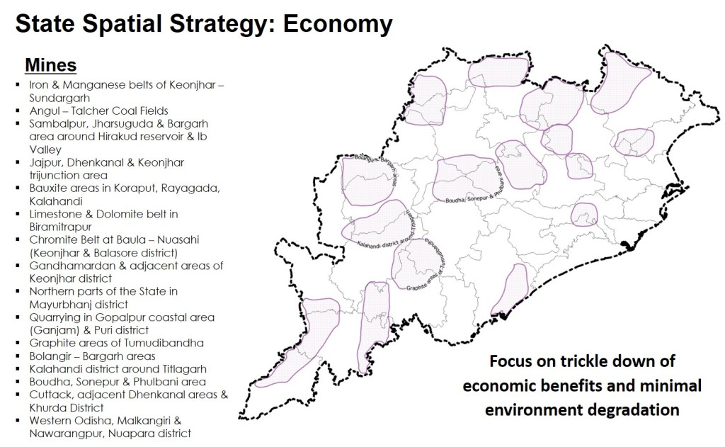
Mines and Quarries
Odisha is emerging as a key state for mineral and metal-based industries, with leadership already established in iron, steel, aluminium and other Ferro alloy productions along with a strong base in coal-based power generation.
Whereas both states will ensure that activities such as mining and quarrying are carried out without any over exploitation and over extraction, with due consideration to environmental and socio-economic parameters. Odisha will specifically consider trickle down of economic benefits and minimal environment degradation in mining belts and areas as depicted in the image below.
Tourism
Tourism is one of the main contributors to Odisha’s economy (approximately 13 per cent of its’ GDP). As per National Council of Applied Economic Research, 2015, Odisha ranks third in terms of intensity of overnight domestic tourism, with an average of 541 trips per 100 households, as compared to the all-India average 418 trips per 100 households (29 per cent higher).
Odisha intends to promote tourism in a mission mode for economic development, inclusive growth, employment generation, and social equity, integration, resulting in eradication of poverty by raising income levels of its citizens.
The key themes for promoting tourism will include beach, eco-tourism, heritage, religious, knowledge conventions and business, medical and wellness, caravan-cruise, and adventure tourism. Odisha has identified 357 major tourism destinations and categorised them on tourism footfall basis as
- Group A (more than 2.5 lakh tourists/annum) 43 destinations spread across 18 districts
- Group B (between 1 to 2.5 lakh tourists/annum) 80 destinations spread across 26 districts
- Group C (less than 1 lakh tourists/annum) 234 destinations spread across 30 districts
The 357 tourism destinations include the themes of eco-tourism (15), beaches (13), Buddhism (16), cultural heritage and skills (6), 35 destinations of heritage and archaeological importance, 104 leisure and scenic spots, and 147 religious centres.
These destinations can be accessed from 20 major base cities/entry points/ district headquarters including the state capital of Bhubaneshwar. The districts of Cuttack, Ganjam, Balasore, Puri, Khurda, Mayurbhanj, Jajpur, Kalahandi, and Keonjhar have the maximum tourist destinations.
Ecotourism spots in select districts, such as Anjar in Keonjhar, Sidhamula in Nayagarh, Ansupa in Cuttack, Mahavinayak & Olasuni in Jajpur, Nrusinghnath in Baragarh, Pakidi hill, Saluapali & Lalsing in Ganjam, Manchabandha in Mayurbhanj, Dhaltangarh in Jagatsinghpur and Saptasajya in Dhenkanal will be promoted to attract nature lovers. The state will focus on creating employment opportunities by engaging local communities for maintaining the facilities like nature trails, watch towers, interpretation centres etc.
In addition to above, Odisha is promoting destinations in the triangle of Puri – Konark – Chilika Lake with investments of about INR 500 crores.
In both states, majority of tourist sites fall in forest, coastal areas, and other eco-sensitive areas, spatial planning of such areas will be undertaken on a priority basis in a manner that promotes tourism as well as minimises conflicts with environment and other zones.
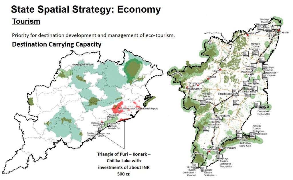
Tamil Nadu identifies tourism as a specialised industry that boosts local employment opportunities, promotes preservation of monuments, heritage properties and eco-sanctuaries and helps survival of traditional art forms, crafts and culture. With five World Heritage Sites declared by UNESCO, and diversified tourist attractions (temples, mountains, waterfalls, beaches, monuments, wildlife, hill stations, art, culture, tradition, cuisine and heritage. Importance will be accorded to development of heritage tourism destination (25 priority locations as mentioned in the vision 2023).
Infrastructure
Good infrastructure guides/boost economic development, societal outreach and integration of regions. At the same time, it results in conflicts with environment. Furthermore, infrastructure is not a domain of one individual department. Hence, it is important to find a fine balance of sustainability through inter-sectoral coordination.
Each state will ensure that all relevant sectoral departments come together and coordinate environment friendly infrastructure development with equitable and affordable access to all.
Both states intend to ensure that all priority infrastructure projects are completed in timely manner. The focus list of infrastructure projects for each state is mentioned below.

Odisha
- Roads: Development and widening of state highways and PPP based road projects with priority allotted to the roads as part of East Coast Economic Corridor and segments from Bhubaneshwar to Paradip, Cuttack to Paradip, Bhadrak – Kothari – Aredi, Bisoi to Rairangpur. Focus will be given to town bypasses and flyovers for all major towns falling along these corridors.
- Railways: Rail-links will be strengthened, and frequency of trains will be increased with support from Ministry of Railways, Government of India. Angul – Chhendipada Coal Railway Corridor will be developed on priority basis.
- Airport: Capacity of Bhubaneshwar international airport will be augmented along with development of airport at Jharsuguda. 17 existing airstrips spread across 14 districts will also be taken up for development under Regional Connectivity Scheme of Government of India. Helipads in all District Head Quarters will be developed to facilitate disaster mitigation programs as well as VIP visits.
- Ports: Development and investments in the ports of Paradip, Gopalpur, Dhamra, Jatadhar, Chudamani, Ashtaranga and Subarnarekha will be taken up on fast track basis with investments from private sector and PPP basis. The ports of Bhichitrapur (Balasore), Bahabalpur, Chandipur, Inchudi, Baliharachandi, Palur, and Bahuda will also be prioritised for development along with fisheries port/jetty development at Balaramgarhi (Bahabalpur), Ashtaranga and Chudamani generating employment for 2000 people each.
- Logistics: Multimodal Logistics Parks at Paradip, Angul, Rourkela, Ganjam and Inland Container Depots at Paradip, Rayagada, Kalinganagar and Dhamra will be developed on priority basis. Storage and warehousing network will be strengthened in the districts of Angul, Baleshwar, Bhadrak, Cuttack, Deogarh, Dhenkanal, Ganjam, Jagatsinghpur, Jajpur, Kendrapada, Keonjhar, Khurda, Nayagarh, Puri, Sambhalpur and Sundergarh.
- Waterways: A riverine port in Mahanadi will be developed at Mahakalpada.
- Energy: Solar Parks will be developed in the districts of Angul, Baleshwar, Boudh, Deogarh, Kalahandi and Keonjhar.
- Water Supply: Mega rural water supply projects will be developed on priority basis in the districts of Angul, Bolangir, Baleshwar, Bhadrak, Cuttack, Jagatsinghpur, Jajpur, Keonjhar, and Puri.
- Urban Infrastructure: Investments under the smart cities scheme of Government of India will be undertaken on priority basis for Bhubaneshwar and Rourkela. Urban water supply and sewerage systems in Rourkela, Berhampur and Sambalpur will be upgraded on priority basis. Affordable housing will be developed on PPP basis in Bhubaneshwar and Rourkela. Services for regional solid waste management for 12 (already identified) clusters will be invested in on priority basis.
Tamil Nadu
- Roads: Development of 2,000 km expressways and widening of 5,000km of state highways to 4 lanes and 16,000 km of roads to 2 lanes. Some of major projects include Chennai – Bangalore Expressway and the six/eight lane triangular corridor: Chengalpet (Chennai) – Thoothukkudi (via Tiruchirappalli and Madurai), Thoothukkudi – Coimbatore (via Madurai and Dindigul) and Coimbatore – Chengalpet (via Tiruppur, Erode and Salem)
- Railways: High speed rail link connecting towns with population higher than 5 lakh, doubling and electrification of all railway routes, and dedicated freight corridors for all ports including Sriperumbudur – Guindy freight line, Chennai – Tuticorin freight corridor, and Chennai Bengaluru freight corridor
- Airport: Greenfield Airport Complex in Chennai with a capacity of 40 million passengers and upgrade to international airports in Trichy, Coimbatore & Madurai with a capacity of 10 million passengers each
- Ports and Logistics: Three greenfield multi-user, multi-cargo ports with a total planned capacity of 150 million tons in Cuddalore, Nagapattinam and Mannapad regions. Logistics parks including container terminals and LNG terminals at ports of Chennai, Ennore and Colachel, ICDs at Sriperumbudur, Ariyalur / Perambalur, and RO-RO cum Multipurpose Berth and Multilevel Car Park at Chennai and Ennore Ports
- Waterways: National Waterway-4 is currently being developed and the North and South Buckingham Canals form part of this route for transporting fertilizers and salt
- Energy: Add 20 GW of thermal power generation capacity, 10 GW of solar/ wind power generating capacity, smart grid and transmission systems, and telescopic tariff reforms to ensure affordable access to all
- Health Care: Three Medi-cities (Chennai, Perundurai & Madurai), medical colleges in all districts, five nurse training institutes and strengthening of Ayurveda, PHC/ UHC/ CHC and hospital network
- Education: Establish and upgrade higher secondary schools in the backward districts of Ariyalur, Perambalur, Theni, Tirunelveli, Villupuram, Tiruvarur, Dharmapuri and Pudukkottai and integrating vocational/skill training programme in school curriculum
Society
Settlements
All human activities are a function of human settlements. Whatever the land use, the need to have plan and manage nature, arises due to its interaction with human settlements. Human settlement patterns and hierarchies directly correlate with economic and social opportunities, as well as resource availability. Priority settlements in a region influence considerations towards essential infrastructure, carrying capacity, envisaged timelines, resource availability and flows, and implication on environmental resources etc.
Whereas the total land under built-up area in Tamil Nadu has seen a growth estimated to over 40 per cent, the total land under built-up area in Odisha has seen an uncontrolled and unprecedented growth estimated to about 115 per cent between 2005-06 and 2016-17. With growing levels of urbanisation and demand for land by industrial, commercial and residential activities should be met from marginal and low productive lands.
To counter market forces, especially in Tamil Nadu, the states will ensure direct interventions (preventing diversion of fertile lands, landscape preservation act, permissions for new industrial units, etc.) and indirect government interventions through regulation of land use like tax concessions for setting up industries in low productive regions and disincentives for locations beyond development priority zone boundaries.

Population
The population of Tamil Nadu is expected to start stabilizing during the decade of 2021 – 2031. It is estimated to be in the range of 65.58 million to 71.49 million (based on medium and high variations in growth respectively) with a likely urbanisation rate of 65%. (Sridharan, 2018).
In case of Odisha, the population is expected to start stabilizing during the decade of 2041 – 2051. It is estimated to be in the range of 44.74 million to 46.61 million (based on low and high variations in growth respectively) by 2041. (Sridharan, 2018). It is further estimated that if the current density trends continue, Odisha will require an additional one per cent of its total geographical area only for built-up / settlements.
Tamil Nadu
Urban Settlements
The pace of urbanisation in Tamil Nadu is well depicted in the growth of its towns and reduction in number of villages as 338 villages gave way to 265 census town between 2001 and 2011 (the yellow dots in the image). Between 1951 to 2011, the population share of class I towns in the state increased from 51.71% to 60.72 per cent as their numbers rose from 7 to 32m and collectively the population share of Class IV, V and VI towns rose from 10.48% to 18.87% during the same period with an increase in number of towns from 84 to 606. During the same duration, collectively the population share of class II and Class III towns reduced from 37.81% to 20.40% as their numbers increased only marginally from 131 to 186.
The settlement hierarchies have started giving way to agglomeration of smaller towns around bigger urban centres and villages to census towns (see image with clustering of yellow dots). An estimated addition of 270 census towns is expected in the 2021 census indicating extensive urban sprawl. Majority of the census towns are rapidly coming up in the belts of along the Chennai Bengaluru corridor, Coimbatore – Salem Corridor, Nagercoil – Tirunelveli belt, and Madurai Virudhunagar belt (the grey hatches in the image show corridors).
The 12 smart cities (check for red stars in image) will be developed as city regions in the forms of nodes for overall urban hierarchy in the state with particular focus on Chennai agglomeration, Agglomeration of Coimbatore – Tiruppur – Erode – Salem, Madurai, Tiruchirapalli, Tirunelveli, Thoothukkudi, Vellore-Ranipet, Cuddalore and Hosur.
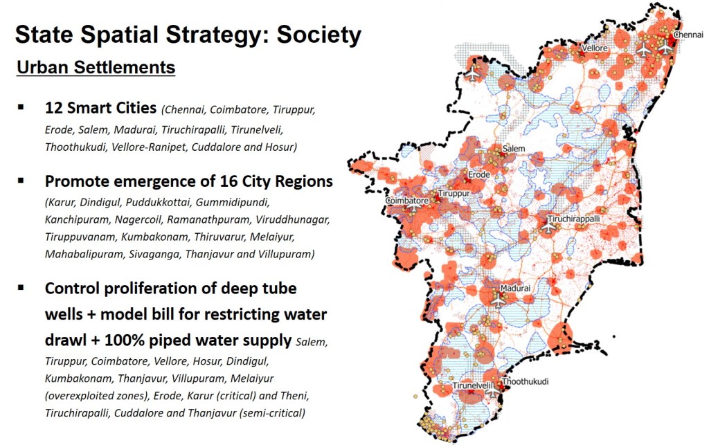
The state will prioritise city regions of Karur, Dindigul, Puddukkottai, Gummidipundi, Kanchipuram, Nagercoil, Ramanathpuram, Viruddhunagar, Tiruppuvanam, Kumbakonam, Thiruvarur, Melaiyur, Mahabalipuram, Sivaganga, Thanjavur and Villupuram as emerging nodes.
The state will focus on limiting urban sprawl (all the light red shaded areas in the image indicate future urbanisation / urban sprawl extents) to conserve natural drainage pattern with strict development control guidelines and building codes.
Extensive urban sprawl indicates extensive dependence on underground water. 10 priority towns (Salem, Tiruppur, Coimbatore, Vellore, Hosur, Dindigul, Kumbakonam, Thanjavur, Villupuram, Melaiyur) fall under overexploited zones whereas Erode and Karur fall under critical and Theni, Tiruchirapalli, Cuddalore and Thanjavur under semi critical zones for ground water.
Controlling proliferation of deep tube wells (confined aquifer) and exploring a model bill for restricting water drawl (blue polygons with horizontal lines indicate aquifer conservation zones), managing and conserving ground water resources and aquifers in these areas complemented by 100 per cent coverage of piped water supply will be ensured to control further urban sprawl.
A comprehensive Agricultural Land Preservation Act will be enacted to protect fertile farmlands from speculative activities in land markets especially in the urban fringes of city regions (light red areas in the image).
Rural Settlements
The state has an objective of being at par with European standards for HDI in rural areas as well. Rural settlements will be looked at as economically, socially and physically sustainable spaces with improved quality of life of people living there.
Special attention will be given to rural settlements within city regions while preparing various settlement level spatial plans in addition to the identified five Rurban clusters for priority development (Kuthambakkam, Vaniyangudi, Velayuthampalayam, Madukkarai, and Suthamali).
Odisha
Urban Settlements
The pace of urbanisation in Odisha has been slow. Urban settlements are sporadic and have predominantly developed around major government investments and interventions in the form of pockets. Corridors of growth are emerging slowly.
Considering the shift of economy from agriculture to service and industry sector, urban settlements will play an important role in future for providing alternate livelihood opportunities. With rural to urban migration set to increase, housing will become integral to strategic development models for ensuring shelter to homeless including temporary migrants, through provisioning of permanent residential economically weaker section (EWS) and low income group (LIG) units as well as rental housing.
The state has nine development authorities (DAs) which are strongly associated with the relatively highly urbanised districts or regions. These include Bhubaneshwar, Rourkela, Behrampur, Cuttack, Sambalpur, and Puri – Konark, Talcher – Angul, Kalinganagar and Paradip. Furthermore, there are seven regional improvement trusts (RITs) including Balasore, Bhanjanagar, Dhenkanal, Jagatsinghpur, Kendrapada, Jeypore and Jharsuguda and 44 special planning areas (SPAs).
Bhubaneshwar and Cuttack form a rapidly developing agglomeration inviting a lot of immigration. The increasing prominence of Puri for Tourism in recent years has given rise to possibility of their triangular agglomeration.
The investments coming up in Paradip have increased the pace of growth of Kendrapada and Jagatsingpur indicating the emergence of a corridor from Bhubaneshwar – Cuttack – Jagatsinghpur – Paradip – Kendrapada. With an increasing focus on Jharsuguda, and recent declaration of Smart City in Rourkela, the existing developments are picking up pace in Sambalpur and Sundargar.

The state will focus on densifying the existing urban areas as city regions. Priority will be accorded to city regions of:
- Bhubaneshwar – Cuttack – Jagatsinghpur – Paradip – Kendrapada corridor
- Sambalpur – Jharsuguda – Sundergarh – Rourkela corridor
- Behrampur – Chattarpur – Ganjam – Hinjilicut and nearby SPAs
These are shown as dark shade of red in the above image)
- Kalinganagar, Talcher – Angul, Jajpur, Bhadrak and Balasore as future city regions (shown as medium light shade of red in above image)
In addition to above, growth centres in terms of Puri, Dhenkanal, Bargarh, Subarnapur, Bolangir, Titilagarh, Bhawanipatna, Nabarangpur and Jeypore will also be developed to attract migration and provide livelihood opportunities. (shown as lightest shade of red in above image)
Odisha will also focus on limiting urban sprawl to conserve natural drainage pattern with strict development control guidelines and building codes. The state will focus on providing 100 percent coverage of piped water supply.
Rural Settlements
The state has an objective of improving HDI in rural areas. Rural settlements will be looked at as economically, socially and physically sustainable spaces with improved quality of life of people living there.
Special attention will be given to rural settlements within aforementioned city regions while preparing various settlement level spatial plans in addition to the identified Rurban clusters for priority development viz. Dahita (Bargarh), Khallikote (Ganjam), Kotagarh (Kandhamal), Murtama (Nabarangpur), Sibtala (Bolangir), Kharmunda (Sundergarh), Ranipad (Khurda), Samsingha (Jharsuguda), Tala Basta (Cuttack), Thakurmunda (Mayurbhanj), Utkela (Kalahandi), Mirichamal (Koraput), Puttasingi (Rayagada) and Raibania (Baleshwar).
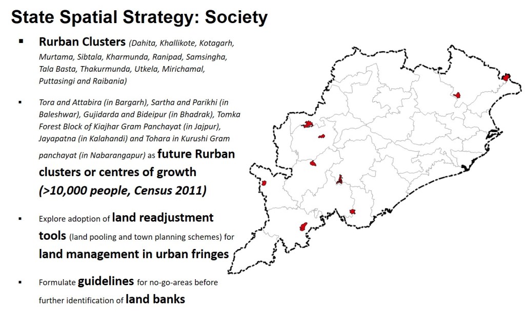
The state has declared the Rurban clusters as special planning areas under the Odisha Town Planning and Improvement Trust Act 1956 (Odisha Act 10 of 1957). (shown in image above).
In addition to above the Villages of Tora and Attabira (in Bargarh), Sartha and Parikhi (in Baleshwar), Gujidarda and Bideipur (in Bhadrak), Tomka Forest Block of Kiajhar Gram Panchayat (in Jajpur), Jayapatna (in Kalahandi) and Tohara in Kurushi Gram panchayat (in Nabarangapur) will also be prioritised as future Rurban clusters or centres of growth as all these villages have a population in excess of ten thousand people (Census of India 2011).
Land Management in Urban Fringes for both states
The peri-urban areas or fringes of cities and their agglomerations are fast transforming into haphazard growth, unauthorized colonies, informal settlements, piecemeal commercial and social amenities development and inadequate basic infrastructure and social amenities. Land management instruments are central to urban development, expansion as well as redevelopment of cities. Such instruments should be equitable, effective, and efficient and time bound.
Whereas, both states use land acquisition instruments under RFCTLAR&R Act 2013, in terms of compulsory acquisition and negotiated land acquisition (extensively used by Tamil Nadu Housing Board), adoption of land readjustment (land pooling and town planning schemes) and transferrable development rights will be explored in future to reduce costs of development.
Land Banks
The Odisha Industrial Infrastructure Development Corporation (IDCO) has been at the forefront of industrial land allotment, creating investor ready infrastructure, investment promotions and developing major infrastructure facilities across various sectors in Odisha.
As on date, IDCO has set up 106 industrial estates across the State and is in the process of developing new industrial estates across various locations of Odisha. Moreover, IDCO is developing various sector specific industrial parks and industrial regions. To meet the growing demands for industrial set up, in a unique move IDCO is creating a land bank of one hundred thousand acres. Till date 64,021 acres of land inclusive of government and acquired private lands have been allotted to the mega projects (till May 2019).
If required both states intend to identify land banks for priority development purposes under RFCTLARR Act, 2013. Odisha will additionally consider the relevant provisions of Odisha Scheduled Areas Transfer of Immovable Property (By Scheduled Tribes) Regulation, 1956 (OSATIP) (Amendment of 2012) and The PESA Act, 1996 in Scheduled Areas.
Both states will avoid unnecessary pooling of land into land bank and all land banks will be linked to development priority zones. However, new land banks will not be created from the sole perspective of creating a Development Priority Zones.
Both states will formulate guidelines for go-no-go-areas on priority basis and make them publicly available before initiating the process for identification and acquisition of additional land banks.
Socially Vulnerable
The socially vulnerable includes the population living below poverty line, socially and economically backward, young children and vulnerable women and old people. Both states intend to incentivise and ensure easy access to microfinance for setting up micro-enterprises to strengthen resilient and alternative livelihood patterns.
In case of Tamil Nadu, the districts of Dharmapuri, Perambalur, Ramanathapuram, Virudhunagar, Ariyalur, Karur, Krishnagiri, Namakkal, Theni, Dindigul and Thanjavur display the highest incidences of poverty based on the Multidimensional Poverty Index. For meeting the state target of reduce percentage of population below poverty line to below 8% by 2022 and 3% by 2030, particular focus will be given to the districts of Perambalur, Ramanathapuram, Ariyalur, Theni, and Thanjavur as they also fall in the lower range of per capita incomes. The districts of Virudhunagar, Karur and Krishnagiri will be focussed from the point of view of improving equity in distribution of resources and opportunities. Tamil Nadu has a target of having 6.46 lakh self-help groups (SHGs) by 2020, and 2.8 lakh SHGs availing INR 27,000 Crores of micro-finance credit.

In case of Odisha, the districts with scheduled areas will be focussed from the point of view of improving equity in distribution of resources and opportunities. Incidences of poverty are much lower in urban areas (17.29 percent of population below poverty line) as compared to rural areas (35.69 percent of population below poverty line) hence, guided urbanisation will be a strategy for Odisha to tackle poverty.
Tribal Sub Plans will prioritise sectors such as demography (e.g. improvements in sex ratio in children of age 0-6, infrastructure (for education, housing and health), agriculture, horticulture, animal husbandry (veterinary institutions), and irrigation and drinking water facilities. Convergence of resources for ensuring alternative employment and skilling will be priority of the State as part of family-oriented employment and income generating schemes.
The state will utilise spatial and land use planning tools and baseline mapping especially in scheduled areas for distribution of social infrastructure (medical colleges & hospitals, dispensaries, health centres, sub-centres, maternity centre, child welfare centre, stadiums, sport clubs, community halls etc.)
The transfer of tribal lands in scheduled areas of Odisha is governed by the Odisha Scheduled Areas Transfer of Immovable Property (By Scheduled Tribes) Regulation, 1956 (OSATIP) (substantially amended in 2002). The OSATIP contains stringent provisions prohibiting alienation of tribal lands. With the gram panchayats playing a key role, focus will be on strengthening implementation of The PESA Act, 1996 in Scheduled Areas to facilitate the processes.
Both states will increase emphasis on extremely vulnerable households of artisans for Geographical Indicator tags. Both states will also map Village Commons and ‘Poramboke’ land (in case of Tamil Nadu) directly related to vulnerable population (used for sourcing firewood, cattle grazing, and medicinal grass, etc.) to ensure complete control/restriction on their transfers in Geographical Indicators. The states will also avoid allocation of such lands for other sectors including industrial, permanent tourism facilities and/or other social infrastructure related to education, health etc. in general.
State Spatial Strategy Plan (Map)
A state spatial strategy plan is essentially a combination of each of the above spatial representations of the priorities. Such a map enables visualisation and correlation of various sectoral decisions and plans.
The map essentially highlights the broad boundaries of development priority zones, the preservation and conservation zones, the transition and buffer zones for environment as well as urbanisable areas. It also provides the broad mapping of important investment decisions in terms of infrastructure and industries as well as disaster proneness.
The entire map is made on a background of land use land cover (1:250,000 scale) base map as indicated in Chapter 14.
Check out the draft maps for the States of Odisha and Tamil Nadu below.
Draft Odisha State Spatial Strategy

Click here to download the A0 size PDF version (35 MB)
Draft Tamil Nadu State Spatial Strategy
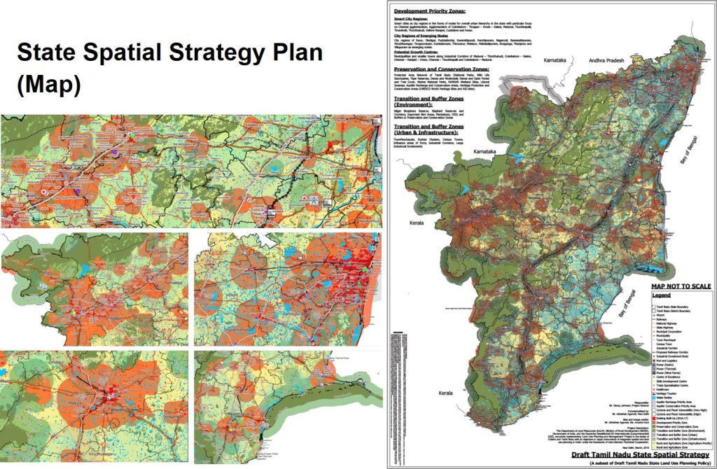
Click here to download the A0 size PDF version (160 MB)
What is the use of these maps?
The maps are prepared on an open GIS platform. Each feature (point, line, polygon) can be given attributes in terms of area, size, length, population, investment, timelines, etc. as desired. Queries can be generated to rapidly arrive at varied answers.
A few indicative questions one may want to explore include:
- Which areas have overlapping investment for irrigation as well as development priority for urbanisation purposes? – the answer would indicate a conflict and inefficient use of irrigation planning and investments in soon to be urbanised areas.
- How much agricultural / forest / eco sensitive areas overlap with development priority areas? – the answer would indicate the interventions that need to be focussed on for safeguarding natural environment.
- Which locations are overlapping with mining, elephant reserves and agriculture (based on specific crops if we have the data as attribute) – the answers will reflect areas with future potential of human wildlife conflicts?
- Queries can also be as simple as which city or investment region witnesses the maximum investment in industries (select category) over a period of next 5 years. The answers would effectively show investment priorities and patterns along with an indication towards possible future job opportunities and migration patterns.
Go ahead, be creative, formulate your own questions.
We can now look at the framework for Regional Spatial Strategy and Planning. Click here.

One thought on “Chapter 16: State Spatial Strategy”