This is a series of nineteen articles on Hierarchical Spatial Planning Framework (Land Use Planning and Management). The articles highlight the need of a public policy on land use and details out an approach to formulation of a Land Use Planning Policy based on experiences in India.
Click here to start reading.
Patterns of human use of land effect a wide variety of outcomes – ranging from economic development, urbanisation, social upliftment etc. However, unplanned, and unscientific use of land can lead to ecological imbalance, climate change, social unrest, disasters like drought or floods, economic disparities, and social imbalance between urban and rural communities.
One of the most crucial resources for development activities, land, however, is finite. For example, India has over 17 per cent of world’s population living on about 2.4 per cent of the world’s geographical area. The per capita availability of land in India has reduced from 0.91 Ha in 1951 to 0.27 Ha in 2011.
With increase in population and possibility of shrinking land mass due to increased coastal erosion and floods due to climate change, the per capita availability of land is expected to reduce further to 0.20 Ha by 2035 (State of Indian Agriculture 2015-16, MoA&FW, GoI).
Growing population and economic development require clean water, food, and other products from natural resources which pose high pressures on the land resources. This is increasingly becoming a concern in terms of degradation of land and negative environmental impacts.
Migration to urban areas and non-farm employment has become priority for economic development. State Government’s in India are increasingly focusing on developing economic / industrial corridors and improving urban areas for habitation purposes. Such developments are being promoted in partnerships with the community, national and international private sector, bilateral and multilateral agencies, as well as its state governments through various schemes. Some key schemes include Smart Cities, AMRUT, HRIDAY, PMAY – urban, Sagar Mala (major and minor port projects), Bharat Mala (National Highways and Corridors), Udaan (Airports), NIMZ, Logistics Parks, SEZs, IT Parks etc. and other socio-enviro-economic planning approaches.
At the same time, the states have a need to plan and improve rural economies and infrastructure. Schemes like integrated watershed management, PMGSY, PMKSY, Rurban and developing other rural and agriculture infrastructure on hub and spoke models and network concepts provide support to them.
Judicious use of land resources has gained foremost significance in all developmental purposes. Increased pressures on land and water resources, and experiences with disasters over the past decades, has necessitated enhanced use of spatial land use planning as a tool for spatial intelligence and guide development as compared to ad-hoc allocation of land for various development projects.
Cities and rural areas need to fulfil their diverse functions in terms of environment, economy, society, food security, etc. Efficient and intelligent use of land as a resource is possible, if consistent and hierarchical spatial planning is applied at different scales involving a multitude of sectors and interest groups.
In a recent study (2018) on land use planning in 32 countries, the Organisation for Economic Cooperation and Development (OECD) highlighted that
- Land use planning decisions are linked to approximately one third of all man-made carbon dioxide emissions since 1850
- Land and buildings on it constitute about 86 per cent of the total capital in OECD countries
- Land use planning decisions are linked to rising wealth inequalities, as small changes in valuations result in major consequences on distribution of wealth
- Land and Land use has a strong sentimental value, as people are attached to land, have a sense of belonging and it is intricately linked to cultural aspects
There are competing and often conflicting demands for land for economic and social needs in the development sector. It is expected that effective land use systems would lead to better consideration of socio-enviro-economic aspects leading to better economic returns, social cohesion, and environmental balance.
Clearly, there is a priority in terms of economic and social development and yet it must be balanced with maintenance of its environment and ecological reserves.
Click here to start reading.
Who is it for?
This series of articles is hopefully a good and interesting read for all planning students, professionals, in India as well as abroad. It is also a good read for all government officials who are working in development and planning sectors, preparing policies, strategies and investment plans for various sectors (whether urban, rural, housing, industrial, agriculture, livestock management, food security, environment conservation and planning, energy, road, highways, ports, airports, other infrastructures,.. you name it. And it has some or the other linkages and relevance to your field.
I hope it is particularly interesting for decision makers who keep trying to bridge the silos at all levels of governance (both vertically and horizontally).
Note that when I say planners here, I do not restrict myself to physical planners having a degree in bachelors or master’s in planning or a doctoral degree etc. I am referring to all those economist, geographers, engineers, architects, environmentalists, water resource experts, development sector professions, infrastructure professionals, government officials in the business of policy and strategy making, including administrators, bureaucrats, and politicians as well.
Click here to start reading.
Why should I read it?
Well… it is pretty much up to you whether you want to read it or not. My motivations would be as follows:
- I feel land is one of the most crucial of all-natural resources, and homo sapiens are literally *@#$ it up.
- I want to understand a policy making process
- I work in a multi-sectoral, multi-disciplinary and multi-cultural environment. Can someone tell me how do I get them all on board?
- I want to learn more about cooperation practices and consensus building
- I want to see an example on the potential of visualisation and spatial representation of social, environmental and economic challenges and solutions
- I want a refresher on some of the planning concepts
- I want to understand / refresh my knowledge about some of the governance structures and concepts in India
- I want to strengthen the planning and decision-making system in my state, and this seems to be an interesting example
- I am a planning student (under/postgraduate/doctoral or even post-doctoral), and I always look for an opportunity to understand my role, governance systems and how various sectors work together. I want to expand my horizons on the concept of planning and policy making
- I am a planning professional, and I am always challenged to clarify my role, position, and potential to the system of governance in India. Contrary to what most people perceive, my job does not end at giving approvals to buildings or making urban design plans or city plans. How do I make them understand that my services are required at all levels of governance, I have the potential to impact all sectors positively?
- Ohh!! It sounds familiar, let us see what they eventually did.
Click here to start reading.
What does it have?
Let us start with an overview of what we have in each chapter. Click on any of the chapters in the list mentioned below to start reading that chapter. You may start with any chapter that interests you. My suggestion would be to go ahead in the sequence.
Chapter 01: Why are we discussing this? A humorous learning process using various images, cartoons, and graphics circulating around on internet (of course, I did not make any of these).
Chapter 02: What is Land Use Planning and Management? The construction of the concept of Land Use Planning and Management. This chapter lays emphasis on benefits of visualisation.
Chapter 03: Flight to Urbanisation. Book a window seat, board a plane and fly to urbanisation as you see the land uses change below you. The birds eye view is the perfect introduction to the concept of levels of plans and scales. This chapter takes emphasis on visualisation a step further.
Chapter 04: Why Land Use Planning Policy? Visualise how land is being used globally, and the sectoral significance in terms of forests, water, agriculture, settlements etc. We also look at how Constitution of India deals with land and introduce ourselves to the relationship of spatial planning with different public policies.
Chapter 05: Land and Sustainable Development Goals (SDG). Who imagined that one policy has the potential to impact 14 goals and 37 targets?
Chapter 06: Approach to Policy Formulation. We visualise the approach to policy formulation, as we understand the concepts of cooperation planning and strategy, the importance of research, baseline and benchmarking, and are introduced to the concepts of working groups, consultations, documentation.
Chapter 07: Stakeholders and Actors – the Departments, their Roles and Mandates. We understand the concept of stakeholders and actors and look at possible stakeholders at National and state levels with two examples.
Chapter 08: Land Use Categorisation. How many land use categories, sub-categories, classifications, definitions, can you think of? So many departments have their own definitions for different land uses. Let us try and bring it all together and learn the power of mind mapping tools in the process.
Chapter 09: Land Use Statistics. What is the land utilisation pattern in India? Let us have a look and understand the sources of information for some key categories.
Chapter 10: Sectoral Policies and the Land Acquisition Process. Ever wondered what various sectoral policies are about? Indian states have such a complex governance system and so many policies, let us look at a select few for two states in India (one highly urbanised and the other being one of the least urbanised). We will also understand the steps if somebody wants to have access to land to setup a project. There are links to policy details. Some may find it boring. Some may be extremely interested. Mind it.
Chapter 11: Department versus Land Use Theme Matrix. Ever wondered? Which department has what control and relationship with each land use category? Let us have a look.
Chapter 12: Working Group – Why and How? This is where we bring all the departments together. We setup the working group and define the agenda for each theme.
Chapter 13: Thematic Consultations. After setting up the working group, let us prepare and undertake the thematic consultations. Let us also document and extract outputs and outcomes from them in terms of visions and land use interaction matrix with an example.
Chapter 14: Spatial Representations of Key Challenges. We are now well into the details for each sector. We have too much information on land use change and sectoral challenges. Let us spatially represent them and use the power of visualisation for easier comprehension. We do it with two examples.
Chapter 15: The Hierarchical Spatial Planning Framework. Aha! The key essence of this series of articles. The objectives and introduction to proposed hierarchical spatial planning framework. And of course, links to details.
Chapter 16: State Spatial Strategy. We look at the evolution of state spatial strategies through the lens of the three pillars of sustainability i.e. environment, economy and society with two proposals/examples. We also get links to the details.
Chapter 17: Framework for Regional Spatial Strategy and Planning. We investigate what a regional plan should have. What zones to create and what all to include in those zones.
Chapter 18: Framework for Settlement Level Land Use Plans. We quickly go through the essence of various well evolved settlement level land use plans and find relevant links to related guidelines. We also focus a bit on the guidelines for transition and buffer zones.
Chapter 19: Institutional Mechanism, Implementation Framework and Timelines. A policy can never be complete if it does not provide for the institutional mechanism and implementation framework along with the timelines. Let us have a look at the new interventions, new mandate, what all structures we need to strengthen and where all planners are required.
Click here to start reading.
Why am I interested in sharing so much knowledge?
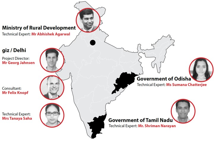
I was associated with Deutsche Gesellschaft für Internationale Zusammenarbeit (GIZ) in India for their Land Use Planning and Management Project from 2016-19. The project was housed with Department of Land Resources, Ministry of Rural Development, Government of India. During my association with GIZ, I led project representation for 12 sectoral national ministries, conceptualised and led formulation of a draft for multi-sectoral land use planning policy, advocated hierarchical spatial planning and governance with due consideration to environment, economy and society in the pilot states of Tamil Nadu and Odisha. Click here to visit project website.
As part of the project we
- Analysed mandates of all 52 National Ministries (now 50) and about 200 departments/PSUs, Institutes etc. to analyse their role and impact on land and land use planning
- Analysed mandates and policies of over 30 different departments in each pilot states to categorise and prioritise departments for role and impact on land related decision making.
- Ensured mapping and analysis of SDGs and integration of 37 targets across 14 different goals as part of the draft policy and project outputs
- Identified and mapped priority areas in pilot states to create a draft state spatial strategy that balances environment priorities with economic and social development priorities
- Conceptualised, sensitised, moderated and built consensus amongst multi-sectoral working groups for policy formulation in each of two pilot states (22 different sectoral departments each, with environment and forest at the core)
- Analysed and documented international practices and experiences of 40 different countries to understand different hierarchical spatial planning frameworks and derived learnings from Indian context
- Conceptualised, facilitated and co-imparted trainings and capacity building programmes to decision makers and planners from multiple sectors in urban sector as well as Strategic Environmental Assessment
- Facilitated and mobilised effective networking, liaison and coordination with research institutes and development agencies, universities, NGOs and created, developed, managed and promoted public forums including seminars and workshops for discussing and promoting land use planning challenges
- Mobilised about 25 academic experts including professors and about 200 students to formulate regional plans for the district of Ganjam (Odisha) and Coimbatore region (Coimbatore, Erode, Nilgiris, and Tiruppur) with a focus on disaster management and environmental planning, respectively.
- Mentored over 15 young professionals / consultants / interns and team members and brought together many experts from diverse cultural, disciplinary backgrounds and nationalities to create a team that could deliver the project.
The project has left lasting impressions on me and my way of working. We struggled a lot while digging and collecting most of the information or setting up the processes. And we learned a lot too.
I have always invested in knowledge management and sharing. I believe it helps in networking, engaging fruitful discussions with people, and creates open and amiable working environments.
Most importantly, I believe sharing my learning and existing knowledge helps me improve my own knowledge and exposure and thereby ensures sound judgement and better decision making.
Click here to start reading.
Acknowledgements
It is never going to be too much to emphasise that this was a collective effort. A special mention for the core team at GIZ
- Mr. Georg Jahnsen
- Ms. Tanaya Saha
- Mr. Felix Knopf
- Ms. Sumana Chatterjee
- Mr. S. Shriman Narayan
Click here to start reading.
And the GIZ administration team for project
- Ms Nishu Tirkey
- Ms Ashima Majumdar
With extensive gratitude to key experts for guidance
- Dr. SK Kulshrestha
- Dr. N Sridharan
- Dr. R Parthasarathy
- Dr. Shrawan Acharya
- Dr. Sudeshna Mitra
- Dr. Asha Rajvanshi
- Dr. Sejal Patel
- Dr. Saswat Bandopadhyay
- Dr. Kajri Mishra
And lots of thanks for extensive support from consultants and interns in data digging, collection, analysis, representation, documentation…
- Ms. Anusha Kant
- Ms. Deeptha Jayakar
- Mr. Ramachandra Panda
- Mr. Kishore Kumar Jayprakash
- Mr. Jayprakash
- Mr. Rajkumar Bopanna
- Ms. Nina Graefenhahn
- Ms. Avleen Kaur
Some more GIZ colleagues from other projects, all other national and international experts and all the professors and students from School of Planning and Architecture, Bhopal who were always willing to explore and go the extra mile (wish you all a very bright future).
And of course, all the government officials who participated to make this happen in the first place.
Click here to start reading.
