We visualise the approach to policy formulation, as we understand the concepts of cooperation planning and strategy, the importance of research, baseline and benchmarking, and are introduced to the concepts of working groups, consultations, documentation. This chapter is part of a series on Hierarchical Spatial Planning Framework
Governments primarily use spatial and land use plans and environmental and building code regulations to affect land use. These instruments function by restricting usage of land but cannot influence how individuals and businesses would like to use land. Many other policies or schemes and planning procedures, which are not causally related to land use planning systems, create incentives to use land in certain specific ways. It is not necessary that such policies correspond to the objectives of land use planning systems.
We quickly go through the essence of various well evolved settlement level land use plans and find relevant links to related guidelines. We also focus a bit on the guidelines for transition and buffer zones. This chapter is part of a series on Hierarchical Spatial Planning Framework
The Town and Country Planning Acts of most states provide for preparation of Development Plans, Master Plans, Zonal Plans, Local Area Plans, Detailed Development Plans, Town Planning schemes, improvement schemes etc. prepared at a scale 1:10,000 or higher indicating precise boundaries of various land uses at local level. Such plans and improvement schemes which are statutory plans and can be enforced at local/plot level.
We understand the concept of stakeholders and actors and look at possible stakeholders at National and state levels with two examples. This chapter is part of a series on Hierarchical Spatial Planning Framework
Who are the right stakeholders and actors? Are they on board and do they support the project? Are they open to the concept and willing to adapt? How important are they? Do they share common objectives? Do they have the right mandate? Are there some who are the key driving force whereas others who play a secondary role? Are there any veto players? Are all actors only from government, or are they from private sector and civil societies also?
A policy can never be complete, if it does not provide for the institutional mechanism and implementation framework along with the timelines. Let us have a look at the new interventions, new mandate, what all structures we need to strengthen and where all planners are required. This chapter is part of a series on Hierarchical Spatial Planning Framework
A State spatial strategy gives impetus to economic growth through urbanization, industrialization as well as many aspects of agriculture and focussed irrigation investments while balancing the environment and social aspects. To facilitate the same, most states need to further strengthen and integrate spatial dimensions in the development process.
What is the land utilisation pattern in India? Let us have a look and understand the sources of information for some key categories. This chapter is part of a series on Hierarchical Spatial Planning Framework
This chapter is specific to Indian scenario. Still, some sections might be relevant to other regions and countries as well.
Various ministries and departments at the National as well as the State Government maintain information on existing land use statistics for their own planning purposes. It is important to understand how these statistics look together at various levels of governance. Such a collation of land use statistics and envisaged/proposed plans is expected to give an interesting insight into the land use scenario for the state as well as the challenges ahead.
Ever wondered what various sectoral policies point to? Indian states have such a complex governance system and so many policies, let us look at a select few for two states in India (one highly urbanised and the other being one of the least urbanised). We will also understand the steps if somebody wants to have access to land to setup a project. There are links to policy details. Some may find it boring. Some may be extremely interested. Mind it. This chapter is part of a series on Hierarchical Spatial Planning Framework
The presence of complex governance systems with multiple sectoral departments means that each departments is in-charge of various development measures. It is highly likely that each department has specific policies or other forms of guiding documents for planning interventions. Some of these policies/guiding documents are expected to directly have an impact on land use, whereas some of them would result in planning processes that affect eventual land use (indirect impact on land use). As most of the departments have such policies in force and decisions are made abiding by these documents, it is important to understand and consider them during the formulation of the land use planning policy for any state or country.
Ever wondered? Which department has what control and relationship with each land use category? Let us have a look. This chapter is part of a series on Hierarchical Spatial Planning Framework
The presence of a complex governance system with multiple sectoral departments and the complex substructure of each indicates that different departments have different mandates functions and powers as far as land use and utilisation is concerned. Whereas some department may have powers and functions covering financial, planning, influencing land use outcomes, other departments may only be affected by decisions of other departments. Furthermore, the powers and functions vested with a department or the lack thereof, may or may not be restricted to a certain category of land use. Hence, it is important to evaluate the roles of various department’s vis. – a – vis. each category of land use.
This is where we bring all the departments together. We setup the working group and define the agenda for each theme. This chapter is part of a series on Hierarchical Spatial Planning Framework
Whoa… We have come a long way. We have spent close to 15 months to come so far.
We are now aware and in agreement with the need of Hierarchical Spatial and Land Use Planning (Click here). We also agree on the significance of a state land use planning policy (Click here and here). We have also seen the importance of Cooperation strategy and the approach that we can adopt for preparing such a policy. (Click here).
This is a Digital Artifact developed for a project assignment submission as part of an online course in “Financing for Development” offer by “edX”.
About the Project:
Assignment: Propose a financing solution that will unlock financial opportunities in a country of your choosing (must be a fragile or conflict state), integrating the IDA Private Sector Window in your solution
Country of Choice: Myanmar
Target Audience: Government officials, policy makers, representatives of public / communities
Focus Area: Rural Poverty Reduction and Sustainable Agriculture through Agri-Infrastructure Development incorporating community based development supported by IFC’s Private Sector Window and a Government Programme.
Method: Role play / imaginary meeting between representatives of Government, community / public forums, IDAs (multi-lateral, bilateral etc.), private sector, NGOs & community organisations, research organisations, banks etc.
They together arrive at a possible multi-stakeholder solution / programme based approach which can be explored or detailed out further.
Disclaimer
All facts and figures as indicated in this document have been sourced from various articles, papers, reports and documents as available on internet in the public domain. Some of the solutions indicated as part of this document have been collated and/or inspired from existing development initiatives in Myanmar and other parts of the world.
The key sources and references are:
Kyosuke Inada, “Catalysing Subnational Development in Myanmar : Balancing Local Preferences with National and Sector Policy”, The Asia Foundation, August, 2014
IFAD: Investing in Rural People – Republic of Union of Myanmar, Country Strategic Opportunities Programme, Document No. EB 2014/111/R.6, March 04, 2014
Thomas Reardon, “Success Strategies for Poverty-Alleviating Rural Development for Myanmar: Lessons from Asian Experience”, Michigan State University, Brief Prepared for National Workshop on Rural Development Strategic Framework Agenda, Naypyitaw, Myanmar, November 18, 2013
Representative of the Government gives a brief introduction of Myanmar
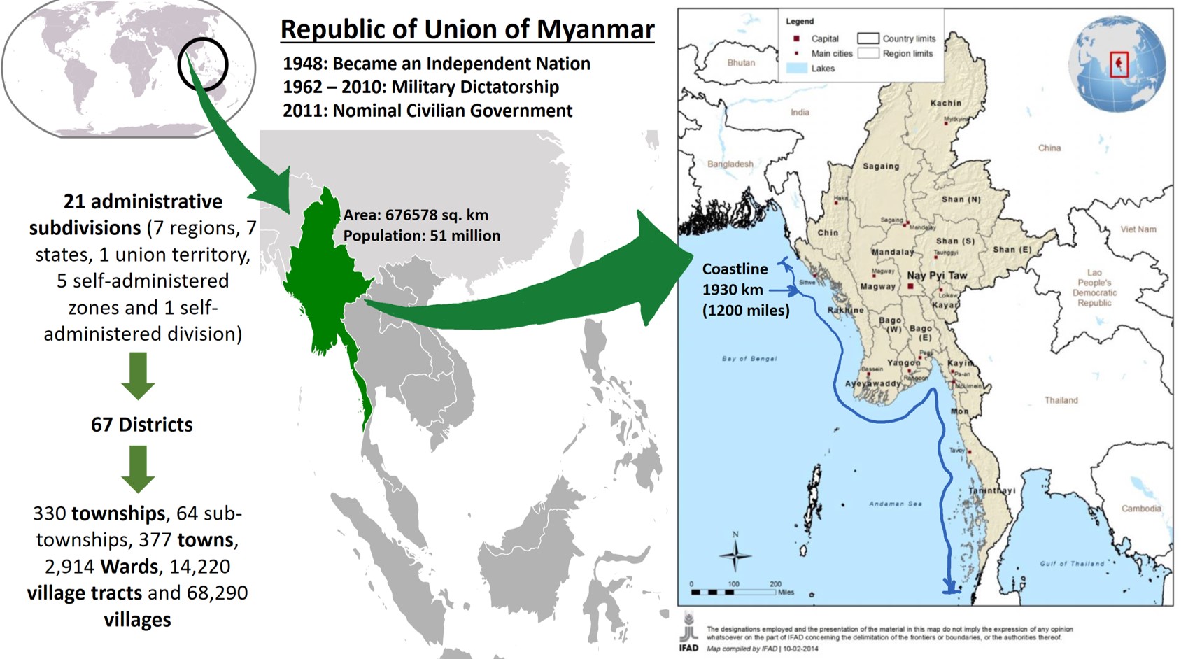
Republic of the Union of Myanmar, is a sovereign state in South East Asia bordered by Bangladesh, India, China, Laos and Thailand. About one third of Myanmar’s total perimeter forms an uninterrupted coastline of 1,930 km (1,200 miles) along the Bay of Bengal and the Andaman Sea. The country’s 2014 census revealed a population of 51 million people. Myanmar is 676,578 square kilometers in size. Its capital city is Naypyidaw and its largest city and former capital city is Yangon (Rangoon).
Myanmar became an independent nation in 1948, initially as a democratic nation and then, following a coup d’état in 1962, a military dictatorship.
For most of its independent years, Myanmar has seen rampant ethnic strife and one of the world’s longest-running and ongoing civil wars. The military dictatorship was officially dissolved following a 2010 general election, and a nominally civilian government was installed. While some former military leaders still have enormous power, the military has taken steps toward giving up control of the government.
Myanmar is divided into twenty-one administrative subdivisions, which include: 7 regions, 7 states, 1 union territory, 5 self-administered zones and 1 self-administered division. The regions can be described as ethnically predominantly Burman (Bamar), while the states, the zones and Wa Division are ethnic minority-dominant.
States and regions are divided into 67 districts. These districts consist of townships that include 330 townships, 64 sub-townships, 377 towns, 2,914 Wards, 14,220 village tracts (groups of adjacent villages) and 68,290 villages.
The mountain chains divide Myanmar’s three river systems: Irrawaddy, Salween and Sittaung. Majority of Myanmar’s population lives in the Irrawaddy valley.
Agriculture in Myanmar
Main stay of country’s economy
Accounts for 60 percent of GDP
Employs 65 – 70 percent of labour force
Once Asia’s largest exporter of rice
Other main crops include pulses, beans, sesame, groundnuts, sugarcane, lumber, and fish
Characteristics of Myanmar’s Agriculture
Slash-and-burn method (shifting cultivation)
Dependent on monsoon season for water
Susceptible to fluctuating weather patterns (e.g. 10% drop in production during prolonged 2011 monsoon season)
Insufficient investment in research, extension, technology transfer, infrastructure development, value chain upgrading and marketing
Lack of remunerative prices to farmers due to structural reasons leading to declining rural incomes
While Myanmar yields more than enough food to feed its entire population, many still go hungry for lack of purchasing power
The income gap in Myanmar is among the widest in the world. As of 2014, according to the Human Development Index (HDI), Myanmar ranked at 148 out of 188 countries
Representatives of Farmers and Local Communities voice their opinion
We face following challenges:
Small land holdings for most farmers
Marginal employment, we don’t have work in other seasons
Single cropping, lack of skill set for other crops / activities
Monsoon dependent, lack of irrigation techniques
Flooding damages our crops as well as agricultural produce
Lack of village facilities
Lack of logistics facilities, bad road and other transport connectivity
Lack of market access and facilities
Rice price fluctuations
Lack of government fund allocation and lack of citizen involvement in local government’s decision making
In efficient public expenditure and corruption
Lack of information
Representative of the Government:
The government recognises these challenges as 70% of poor are located in rural areas. The government has identified following as focus areas:
Priority to provide essential services in rural areas
Develop markets and linkages to local, regional, national and global levels
Modernise and improve agricultural practices and productivity
Improve rural roads with all weather connectivity
Rural electrification to support irrigations measures
Improve river navigation, flood control, and reduce vulnerability to disaster shocks
Skill development to diversify economy, markets, trade, financial institutions
Improve citizen engagement by encouraging community driven investment planning for local infrastructure and services
Improve health and education in rural areas
Representatives from International Development Agencies / Assistance:
(IFC’s Private Sector Window)
We think Myanmar needs to look at options for innovative financing and more involvement of private sector resulting in increased commercial potential of SMEs in agribusiness and farmers by connecting value chains at local, regional, national and global levels
Focus: Agri-food security for small farm holders by
Increasing productivity of small farm holders and improving access to credit, cooperatives
Supporting innovations to develop technology for increasing productivity and reducing water consumption, promote efficient use of fertilizers and explore multiple cropping of farmland
Risk assessment and reduction especially for climate proofing, first loss cover, weather insurance, and support SMEs in investment
Private Sector Representatives:
Agri-business Sector is willing to
Markets: explore business, develop and invest in market facilities and infrastructure
Logistics: backward and forward linkages to markets and agriculture, distribution centres, collection centres, transportation, renting of farm equipment and materials
Invest in granaries, warehouses, cold storage facilities
Invest in research and development in agriculture
Explore Opportunities in Horticulture and Floriculture
But we lack technical and financial resources, the banks also don’t lend us money
Other business (high value)
Lots of funds available under Corporate Social Responsibility funding, but we do not know where, what, when and how to fund. Its not our expertise
Concerns of the Local Financial Institutions / Banks
Expect support from International Development Agencies to gain confidence
Small farm holders to adopt cooperative approach /self-help groups (SHG) for debt funding for logistics infrastructure as well as investments for agricultural modernisation
Project advisory of International Development Agencies to guide debt funding in developing logistics facilities like granaries, cold storage etc.
Loans to farmers for purchasing seeds
Explore pooled debt funds for funding agri-infrastructure projects to reduce our exposure to risks
How to evolve an Environmental and Social Risk Assessment Framework for improving our investment efficiencies by reducing risky investments
NGO / Foundation / Research Organisations:
To act as resource centres for:
Promote cooperative farming and SHG formation
Training & capacity building
Skill Development
Financial literacy of local government, community and MSMEs for efficient use of existing financial resources
Awareness generation and information sharing platforms / networks
GIS based planning and micro water shed management
Best use studies for agricultural land
Research on modernisation of agriculture
Representatives from International Development Agencies / Assistance:
(IFC’s Private Sector Window)
Great!! We look forward to a programme in Myanmar wherein we undertake innovative and blended financing as follows:
Long term and short term financing through support and capacity building of location banking / financial markets to ensure access to financial resources for small farm holders and MSMEs
Equity Capital: to agribusiness supply chain logistics, distribution, food production and process, and other agri-infrastruture
Insurance: First Loss Cover, Weather Insurance
We will also provide advisory services for
Climate proofing and Climate smart agriculture
Data base management
Result based monitoring systems
Environmental and Social Risk Assessment Framework for Banking Investments
Representative of the Government:
I thinks it’s a good idea!! We have a programme with IFAD which focuses on developing four kinds of partnerships:
Structured co-financing with partners: Develop structured co-financing of the country programme, rather than project-by-project co-financing
Partners may include the World Bank, the Asian Development Bank, the European Union, the Japan International Cooperation Agency and the Export-Import Bank of Korea
Focus on infrastructure development, financial services, technologies and capacity-building
Seek climate change financing from IFAD Adaptation for Smallholder Agriculture Programme, the Green Climate Fund and the Global Environmental Facility
Private-sector partnerships with national and/or multinational private sector entities
Business partnerships with agri-businesses for vertical value chain integration based on contractual relationships with smallholder organizations
Financial partnerships with private-sector firms under the corporate social responsibility agenda
Partnerships with national private sector to evolve gradually
Technical partnerships with institutions providing technology and knowledge solutions in favour of smallholders and landless entrepreneurs
Relations with ministries and research institutes
International organizations for providing policy advice, improved technologies, rural financial services and operational services
Advocacy partnerships with civil society organizations or NGOs over a period of time
Additional References
“Burma (Myanmar) – Agriculture”. Encyclopaedia of the Nations
We discuss here (in a series of notes) about developing viable strategy for sustainable development of coastal regions. The planning, though, expected to be seriously handicapped by considerations of prospective climate and ecological changes, still has viability by adopting dynamic strategies, where the broad-based ecological information is holistically integrated with development goals and execution decisions. Satellite data plays a very important role in evolving the decision support system.