
Construction of the concept of Land Use Planning and Management. This chapter lays emphasis on benefits of visualisation. This chapter is part of a series on Hierarchical Spatial Planning Framework
Land use planning and management is a complex word. It needs to be constructed step by step to create a better understanding.
Land: Land is the base for everything, that dry surface of earth, where most of the human activities happen
Land Use: Generally, reference to any and all possible activities that are associated with land, irrespective of ownership, whether natural or man-made, urban or rural, on the surface – in the air – or underground, in the public or private domain, etc.
Land Use Planning: The process of describing, reporting, mapping a baseline of all uses, potentials and weakness of various land uses so as to gain spatial and temporal intelligence; followed by using the same to balance, overview, envision all possible evolutions and thereby increase the possibility of gaining a spatial order that reduces conflicts, respects environment, secures investments and creates social harmony.
Land Use Planning and Management: The practice of all necessary actions, possible coordination mechanisms, and creation of binding frameworks for ensuring a balanced spatial order as envisaged in a land use plan.
Too Complicated??
Luckily, I had the opportunity of working with Mr. Georg Jahnsen (the team leader for my last assignment at GIZ India from 2016 to 2019). He has this great knack for simplifying things by creating easy to understand visuals.
So, let us try the visual approach… it might be easier to understand.
Land
Okay. Let us start with what is land? Many people equate land with agriculture, soil and hence predominantly rural. But that is not so. Land is the base for everything. It is that dry surface of earth, where most of the human activities happen. For that matter, all those wet surfaces (water bodies) that are being used by humans would also come under the definition of Land.

Look at this image above. If we talk about India, the entire geographical area of India is its ‘Land’. Snow covered mountains, other hilly areas, desserts, plains, rivers, coastal territorial areas, water bodies like lakes, marshes etc. it is all land.
In terms of major geographical regions, for India, it may be categorised as:
- The northern mountains (including the Himalayas and the northeast mountain ranges)
- Indo-Gangetic plains (Alluvial plains of Sindhu, Ganga, and Brahmaputra)
- Thar Desert and Salt Desserts (Gujarat and Rajasthan)
- The Peninsular Plateau (Central Highlands, Deccan Plateau, Malwa Plateau, Chota Nagpur Plateau, and the hills of Satpuras, Aravalli, Western and Eastern Ghats)
- Coasts (East and West Coasts)
- Bordering seas and islands
Land Use
There is a common understanding that, I own this land and I can put it to whatever use I want to. In other words, people think that land use is what the owner decides and is causally linked to ownership.
But is it?
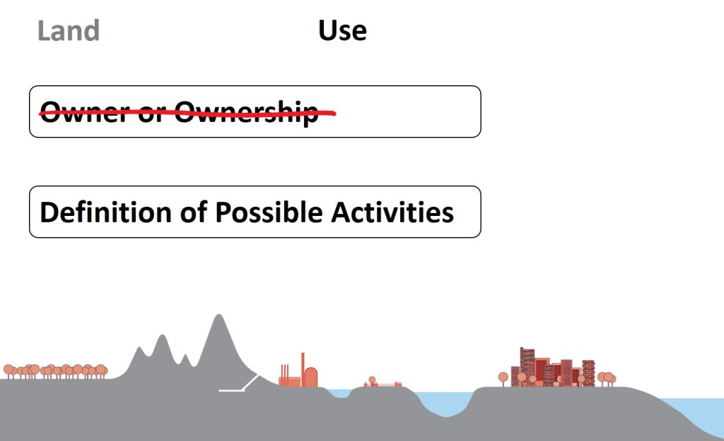
I would rather say, land use is a reference to any and all possible activities that are associated with land, irrespective of ownership, whether natural or man-made, urban or rural, on the surface – in the air – or underground, in the public or private domain, etc.
Urban – Rural
Whether you land is in an urban area or a rural area there can a variety of possible activities that can be allocated to it. In rural areas it can be agriculture, housing, community area, market, government uses like school, dispensary, a lake, forest, plantation, or any other thing. Similarly, in urban areas land can be put to various uses like residential, commercial, institutional, nature, infrastructure, government, open space, public utilities etc.

Natural – Manmade
Generally, we think, human use of land is essentially meaning it is constructed specifically for some purpose like residential, commercial, industrial, infrastructure, public spaces, parks, gardens etc. But think about it, agriculture, fruit plantations, forests, lakes, rivers, desserts, etc. whatever it is in terms of nature, we still derive an economic utilisation of it.

Air – Surface – Underground
Ah, so that means that whatever we are doing on the surface of Land is land use?!
No!!
Consider, a rail-metro tunnel, or an oil pipeline, or an underground parking, or a tunnel road, or water and wastewater pipeline, even natural confined and unconfined aquifers. The list is long. They are all underground.
Consider, airports and helipads. Or even paragliding, sky diving etc. They are all located with a base on the surface of land. But still, the actual activity happens in the air. And there are rules that need to be followed for those activities. They impact and are impacted by the life and activities on land air and water as well.
So, we say, the land use can be related to air, surface and undergrounds as well.

Public – Private
Does that mean, there are some land uses that are public and some that are private? ….. No.
The industry, township, housing, airport, pipeline, water body, forest, farms, schools, hospitals etc. can be owned or developed by the government, local body, community, individual, association etc.

Thanks, Georg for these amazing graphics. (Click here to see more of them)
Land Use Planning
Wikipedia says: ‘Planning’ is the process of thinking about the activities required to achieve a desired goal. It is the first and foremost activity to achieve desired results.
Wikipedia also says: ‘Land-use planning’ is the process of regulating the use of land to promote more desirable social and environmental outcomes as well as a more efficient use of resources. Goals of land use planning may include environmental conservation, restraint of urban sprawl, minimization of transport costs, prevention of land use conflicts, and a reduction in exposure to pollutants. By and large, the uses of land determine the diverse socioeconomic activities that occur in a specific area, the patterns of human behaviour they produce, and their impact on the environment.
How do we go about it?
We start with enumerating all the Land Uses. Following is a 30 seconds list of a few… try it name a few, take a minute and see how many you can come up with. It is interesting and fun.

So how many of them are there?
Hundreds of uses if we go into classification and sub-classifications and sub-sub classifications. (click here to jump to Land Use Definitions, my recommendation – read on… it gets interesting)
And then we must go on describing reporting for each of these, map them in terms of baselines and make and assessment in terms of their potentials, weakness, advantages, challenges, compatibility, conflict etc.
Imagine the amount of papers, documents, and files that we are going to create. Then what should we do? We Visualise…
We try to visualise them by creating a graphic / map to gain a spatial understanding. We create standards for these uses (in terms of definitions, visuals, compatibility, competitiveness, conflicts etc.). And we see how they change temporally (over time).
i.e. we gain spatial and temporal intelligence.
Let us try this with a remarkably simple example.
Most of us have lived or travelled through a city or town at some point of time. So, before we start, let us close our eyes and try to imagine / visualise a hypothetical scenario based on what we have seen and observed in past. Try to imagine how it changed over time, what features were added, what roads were added, what happened to lakes, rivers, forest, farms etc.
Imagine / Visualise a hypothetical scenario…
Most of the settlements tend to come up near a water source. Let us imagine that our hypothetical scenario has lake and a river. The lake is at the edge of a forest. And a stream connects the lake to the river. Now imagine that there is a road that cuts through the forest and crosses the river. There is another road along the northern banks of the river. Let us add a railway line as well, between the river and road.
Each one of us must have visualised something that we want to describe and can do that in maybe five pages and still we will come up with a different understanding of the other persons imagination.
Now, see the image below (these are my sketches, no Georg here, please bear with my bad drawings).

What happened? What has changed?
Just now, you gained spatial intelligence to my hypothetical scenario.
Okay. Let us move a step further. I like hills and mountains. Let us add hills and mountains to the scenario. Some of these hills are within the forest and some are outside. The lake is however surrounded by hills and is at a higher altitude as compared to the river. Hence, the stream flows from the lake to the river.

There was a mine discovered a few decades back which gave rise to a mining based industrial city (big city). The development of the city resulted in upgradation of the roads to highways. This economic development also necessitated the demarcation of an administrative district (In India, a district is an administrative boundary that is generally bigger than a city, may have two or three towns, but is smaller than a state/province – something like a county in a few European countries).

As this Big City started growing along the highways and railways, an industrial township came up in the north-west, and small city in a different district also came up on the south-east and a small town started developing on the south west. As the economy of the big city started diversifying a tourist town in the hills also started developing.
And of course, the rest of the areas practised agriculture, and has smaller settlements with villages all through out. I.e. the lighter shade of green is rural/agricultural area with villages shown as dots.

Now that we have gained this spatiotemporal intelligence, it is time to use it to balance, overview, envision possible evolutions. This will increase our chances of having a spatial order. A good spatial order reduces conflicts, respects environment, secures investments and creates social harmony.
The growth of the big city has been following the highways and railways. And it is expected to continue expanding along them. As the economy is diversifying, and the mine is nearing its exhaustion in another decade, the industrial development around the industrial township has resulted in a sprawl and it is almost contiguous with the big city.
Meanwhile the small town has picked up on IT and Knowledge economy becoming an important centre for academic institutions due to cheap availability of land in absence of any planning norms.
At the same time, the small city has been expanding along the highways as well with people now travelling to the big city for work.
And the tourist town has shown some rapid expansion but is constrained by its geography and its limited resources. Located along the forest boundary, the tourist town must now comply with extensive regulation and prohibition of certain activities due to loss in biodiversity and other negative environmental impacts.

For planning and managing above mentioned challenges, conflicts, and interdependencies, and encouraging investments, it was decided that an Urban Agglomeration Development boundary / metropolitan boundary will be demarcated. This boundary has specifically kept the tourist town out of its purview to discourage its further expansion (there are advantages and well as disadvantages of this decision).

To bring in a spatial order to the rapid sprawl, City peripheral roads and outer peripheral roads have been proposed for development. The area between these two roads is also planned under new town planning schemes and local area plans with roads following ring radial and grid iron patter on case to case basis.
Transport oriented development of planning schemes has been proposed from the big city to the small town and small city. These corridor to small town is expected to become a knowledge corridor in future.
A Rurban centre has been identified on a hub and spoke model to the south of mines and south east of big city to encourage rapid and planned development. Since the area is a flood plain it is still fertile, and agro-industries are being incentivised in this area.
A similar Rurban centre is identified beyond the Urban Agglomeration Development Authority Boundary to guide and encourage future developments and expansion. For the purpose, strengthening of state highway and other district roads are also proposed.
Due to the extensive urban sprawl, the riverbanks have started eroding and hence, disaster reduction measures and river training within big city area is envisaged. At the same time, expecting future impact on the lake a lake catchment preservation and restoration plans is proposed around it.
Similarly, the negative impact on forest and hills is expected to be addressed by allowing, encouraging certain activities while discouraging and constraining certain activities within the buffer at Urban forest boundary. A buffer tree cover is also planned around the mining area to reduce its environmental impact along with landslides and soil erosion. Post mining closure and rehabilitation plan is out of the purview of the said authority.

We have a Land Use Plan. Now what?
Land Use Planning and Management
We must take necessary actions to implement it. Fine. The Urban Agglomeration Development Authority will do it. Right?
Correct. But Partially.
Look closely.
There are five urban local bodies (municipal corporation/ municipalities) in this picture. But there are also so many rural local bodies (village panchayats typically governing a cluster of 1 to 10 villages).
What happens to them when urban area expands? They merge dissolve and get absorbed to Urban Local Bodies. Their budgetary flow changes from rural department/ministry to urban department/ministry. The applicability of various departmental schemes changes.
So what? It is still the same state/province.
Look more closely.
There are national highways and railways. They are under the purview of National Government. The forests are jointly under the purview of governments at national and state level. Some mines are under the purview of mines department and some are under revenue, which one is this?
The lakes are under state government, but what about rivers? Are they cutting across states?
The challenge here is to ensure possible coordination mechanisms and creating binding frameworks.
These coordination mechanisms and binding frameworks need to be ensured across multiple sectors at the same level of governance (national, state and local) as well as vertical cooperation across the three levels of governance.
The following image by Mr. Georg Jahnsen, (GIZ) succinctly summarises this requirement.

This in short (pun intended) is Land Use Planning and Management
Wait a minute. There is still one particularly important thing that needs to be understood.
Scale!!
Let us take the flight to urbanisation to understand it. Take the flight to urbanisation here.

One thought on “Chapter 02: What is Land Use Planning and Management?”